Previous Story
Ante el buen resultado la municipalidad de Toronto aumenta cámaras de control de velocidad en las calles
Posted On 01 Feb 2023
Comment: Off
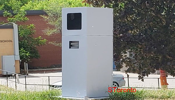 TORONTO.- La Ciudad de Toronto está ampliando su programa de Control de Velocidad Automatizado (ASE, Automated Speed Enforcement) con una nueva ronda de cámaras que comenzarán a funcionar a partir de hoy miércoles 1 de febrero 2023.
La expansión significa 25 nuevas cámaras en toda la ciudad, una para cada barrio. Los últimos dispositivos se unirán a los otros 50 que actualmente están en rotación para ayudar a reducir el exceso de velocidad en las calles y que también dan un ingreso económico a la municipalidad.
Según la municipalidad, dice que las señales de advertencia han estado colocadas desde principios de noviembre en las nuevas ubicaciones. Los letreros deben estar encendidos durante 90 días antes de que las cámaras entren en funcionamiento, la ciudad comenzó a publicar las advertencias el 2 de noviembre de 2022.
Locations for 25 new automated speed cameras:
- Thistle Down Boulevard east of Albion Road (Etobicoke North)
- Martin Grove Road south of Eglinton Avenue West (Etobicoke Centre)
- Mimico Avenue west of Station Road (Etobicoke-Lakeshore)
- Lansdowne Avenue near 108 Lansdowne Ave. (Parkdale-High Park)
- Pritchard Avenue near Batavia Avenue (York South-Weston)
- Sheppard Avenue West west of Keele Street (York Centre)
- Driftwood Avenue east of Jane Street (Humber River-Black Creek)
- Avenue Road north of Elwood Boulevard (Eglinton-Lawrence)
- Gladstone Avenue south of Cross Street (Davenport)
- Dennison Avenue south of Grange (Spadina-Fort York)
- Bloor Street West west of Clinton Street (University-Rosedale)
- Davisville Avenue east of Yonge Street (Toronto-St. Paul’s)
- Queen Street East near Sackville Street (Toronto Centre)
- Logan Avenue north of Wolfrey Avenue (Toronto-Danforth)
- Harrison Road near Vernham Avenue (Don Valley West)
- Sloane Avenue near Draycott Drive (Don Valley East)
- Freshmeadow Drive west of Applegate Crescent (Don Valley North)
- Senlac Road north of Elynhill Drive (Willowdale)
- Main Street south of Swanwick Avenue (Beaches-East York)
- Danforth Road east of Huntington Avenue (Scarborough Southwest)
- Lawrence Avenue East near Canlish Road (Scarborough Centre)
- Birchmount Road north of Bay Mills Boulevard (Scarborough-Agincourt)
- Tapscott Road west of Blackwell Avenue (Scarborough North)
- Orton Park Road south of Ellesmere Road (Scarborough-Guildwood)
- Lawrence Avenue East west of Port Union Road (Scarborough-Rouge Park)
Each city ward will now have three speed cameras that are mainly focused in school zones.
The original 50 cameras are now into their sixth round of locations.
New locations for 50 existing automated speed cameras:
- Kipling Avenue north of Rowntree Road (Etobicoke North)
- Humberwood Boulevard south of Pinecone Drive (Etobicoke North)
- Bloor Street West near 4034 Bloor St. W. (Etobicoke Centre)
- Allanhurst Drive near Mulham Place (Etobicoke Centre)
- Burnhamthorpe Road west of Dundas Street West (Etobicoke-Lakeshore)
- Norseman Street near Lothian Avenue (Etobicoke-Lakeshore)
- Dundas Street West east of Watkinson Avenue (Parkdale-High Park)
- Parkside Drive south of Algonquin Avenue (Parkdale-High Park)
- Keele Street near Nashville Avenue (York South-Weston)
- Emmett Avenue near 75 Emmett Ave. (York South-Weston)
- Keele Street north of Wandle Avenue (York Centre)
- Giltspur Drive near 120 Giltspur Dr. (York Centre)
- Weston Road south of Burgundy Court (Humber River-Black Creek)
- Duncanwoods Drive west of Gracedale Boulevard (Humber River-Black Creek)
- Neptune Drive west of Bathurst Street (Eglinton-Lawrence)
- Glengrove Avenue West west of Glen Castle Street (Eglinton-Lawrence)
- Ossington Avenue north of Churchill Avenue (Davenport)
- College Street near Sheridan Avenue (Davenport)
- Dundas Street West near Carlyle Street (Spadina-Fort York)
- Queens Quay West east of Bathurst Street (Spadina-Fort York)
- Bloor Street East east of Castle Frank Road (University-Rosedale)
- Howland Avenue south of Wells Street (University-Rosedale)
- Yonge Street near Glen Elm Avenue (Toronto-St. Paul’s)
- Russell Hill Road north of Coulson Avenue (Toronto-St. Paul’s)
- Alexander Street east of Yonge Street (Toronto Centre)
- Sherbourne Street south of Wellesley Street East (Toronto Centre)
- Dundas Street East west of Boulton Avenue (Toronto-Danforth)
- Carlaw Avenue south of Queen Street East (Toronto-Danforth)
- Overlea Boulevard east of William Morgan Drive (Don Valley West)
- Fenn Avenue north of Gordon Road (Don Valley West)
- Don Mills Road north of Overlea Boulevard (Don Valley East)
- Fenelon Drive near Karen Road (Don Valley East)
- Old Sheppard Avenue east of Ladner Drive (Don Valley North)
- Van Horne Avenue near Silas Hill Drive (Don Valley North)
- Beecroft Road near Lorraine Drive (Willowdale)
- Hilda Avenue north of Drewry Avenue (Willowdale)
- Gerrard Street East east of Beaton Avenue (Beaches-East York)
- Wolverleigh Boulevard west of Glebemount Avenue (Beaches-East York)
- Midland Avenue south of Aylesworth Avenue (Scarborough Southwest)
- Blantyre Avenue south of Swanwick Avenue (Scarborough Southwest)
- Midland Avenue north of Tara Avenue (Scarborough Centre)
- Dorcot Avenue west of Lyon Heights Road (Scarborough Centre)
- Finch Avenue East west of Birchmount Road (Scarborough-Agincourt)
- Glendower Circuit near Nearwood Gate (Scarborough-Agincourt)
- Brimley Road north of Pitfield Road (Scarborough North)
- Ingleton Boulevard east of Presidents Court (Scarborough North)
- Morningside Avenue north of Danzig Street (Scarborough-Guildwood)
- Dormington Drive north of Ellesmere Road (Scarborough-Guildwood)
- Morrish Road near Starfire Drive (Scarborough-Rouge Park)
- Littles Road south of Rangeley Drive (Scarborough-Rouge Park)
La cámara en Parkside Drive, al sur de Algonquin Avenue, fue el único dispositivo que no se traslado a otro lugar en el otoño pasado. Solo esa cámara fue responsable de aproximadamente el 10 por ciento del total de multas según la última ronda de datos facilitada por la ciudad.
Luego de un accidente fatal en octubre pasado, hubo llamadas para mejorar la seguridad a lo largo de ese tramo de Parkside Drive. Los residentes han pedido durante mucho tiempo un radar fotográfico y un rediseño de la calzada.
En total, el Programa de Control de Velocidad Automatizado de la ciudad emitió más de 48,000 multas hasta agosto y septiembre del año pasado. El infractor reincidente más frecuente recibió 12 multas por exceso de velocidad en Brant Street, al sur de Adelaide.